Queenstown Wharf, located along the Lower Wolastoq (Saint John River), offers paddlers access to multiple adventures in one scenic destination. Just off Route 102, this launch point provides access to the peaceful Otnabog Lake, winding channels around Long Island, and the stunning, wildlife-rich waters of Lower Musquash Island. Whether you're looking for a family-friendly lake loop, a calm channel paddle, or an exploratory trip across the main river, Queenstown has something for every level of paddler.
Wind and motorboat traffic are the biggest hazards you will run into in this area. I would choose either Otnabog Lake or the channel along Long Island if wind is an issue. Both options are more protected. They also have less boat traffic and the boat traffic they do have tends to be smaller. These would be much better options if you have kids with you.
Key Highlights
- Community: Arcadia
- Route Types: Loops & Lakes
- Number of segments: 3
- Difficulty: Beginner to Intermediate
- Total Distance: 5 to 15 km depending on route
- Seasonal Information: All-season, spring until late fall. Paddling is best from late spring through fall. The area is tidal, so route conditions may vary throughout the day. High tide offers the best access to wetlands and side channels.
Directions
From Route 2 near Gagetown, take exit 330 and turn towards Gagetown. Drive south for 25 kilometres on Route 102. When you get close you will see the view of Otnabog Lake open up in the valley on your left. When the road comes down close to the river, look for an older white house on the left that is close to the road. The Queenstown Wharf Road is just past this house on the left. Turn into the road and after a short distance you will come to the wharf.
If you are coming from the south, take route 102 in Grand Bay-Westfield. Drive for 49 kilometres on route 102 and look for the Queenstown Wharf Road on the right. If you start to climb a hill away from the river you have gone too far.
Description
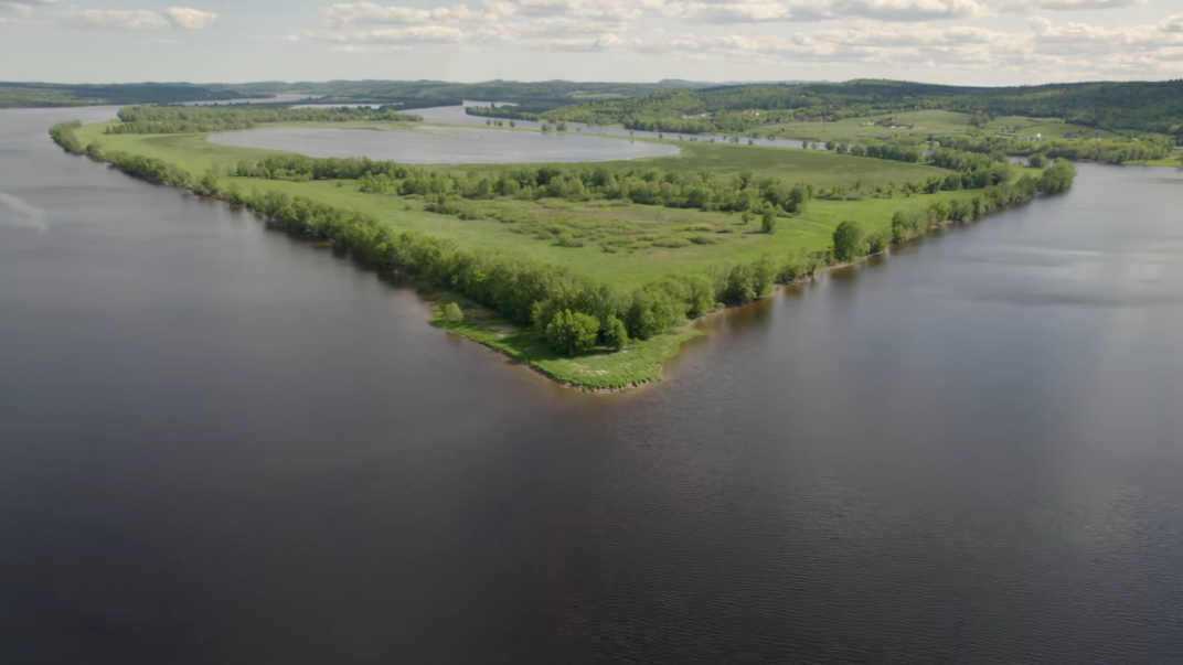
There are 13 old steamboat wharves in the Lower Wolastoq (Saint John River) valley that are maintained by the St. John River Society. There are several more maintained by local municipalities. These steamboat wharves provide important public access points to the river. Queenstown Wharf is one of our favorite wharves to access the river because it provides so many adventure options.
Right beside the wharf on the left (facing the river) is a narrow channel that accesses Otnabog Lake. The lake is separated from the river by a long, narrow berm that used to be a rail line. The lake is surrounded by fields and farmland climbing the hills on either side. A highlight of the lake is the wetland at the far end. Here you will find lots of wildlife and birds. Osprey, eagles and great-blue heron are common in this area. This lake is part of the tidal zone so the character of the wetland will change throughout the day. Plan your trip at high tide and you will have the most water to explore. Circling the lake is an 8 to 10 kilometre loop and is a great option for an afternoon family paddle. Be cautious of the tidal current coming into or going out of the narrow channel that accesses the lake. You may also encounter motorboat traffic accessing the lake. If you want to spend more than an afternoon at Otnabog Lake, check out the Tides Peak Air B&B. Their beautiful cabin and unique silos provide access to the lake. They also have five kayaks that guests can use.
The second paddling option from Queenstown Wharf is to turn right and follow along the narrow side channel of the Wolastoq (Saint John River). This channel is separated from the main river channel by Long Island, and gets less boat traffic than the main river. It also provides the option to check out small channels, lakes and wetlands that are in Long Island. These small, grassy lakes provide amazing wildlife viewing but may be shallow depending on the tides. Make sure you are cautious of the tidal currents flowing in and out of these lakes and wetlands.
The third option, and the one I chose on my last visit, is to go straight off the wharf along the top of Long Island. This takes you out to the main channel of the Wolastoq (Saint John River). Here you will find the most boat traffic and you will have to be cautious of their wakes. They are sometimes larger boats, and you don’t want to swamp your boat. After passing by the sandy point of Long Island you will see the shores of Lower Musquash Island across the main channel. The lake in the middle of this large island was my goal for the day. I crossed the main river and turned right, making my way down along the shore. Beautiful hardwoods line the island. Eventually I came to a channel on the left that feeds the lake. The channel is surrounded by mostly grasslands. On my visit I passed a flock of black ducks, a family a beaver, and saw several large eagles. When I got into the lake, I was amazed to see the shallow waters rippling with what I later learned was spawning Blueback Herring. You can watch the video from my adventure here.
Wind and motorboat traffic are the biggest hazards you will run into in this area. I would choose either Otnabog Lake or the channel along Long Island if wind is an issue. Both options are more protected. They also have less boat traffic and the boat traffic they do have tends to be smaller. These would be much better options if you have kids with you.
Queenstown Wharf to Otnabog Lake Loop
Queenstown Wharf to Long Island Back Channels
Queenstown Wharf to Lower Musquash Island
Nearby Amenities
- Tides Peak AirB&B